
Infographic—who uses electronic medical records, and why?
Infographic—who uses electronic medical records, and why?
This is a simple project, just completed, for a one-page flyer (print and digital) to advertise a management workshop for a consulting firm. Pictured are the original document—containing all the necessary info but text-heavy and without a unified style—and the reworked version.
The original can be downloaded from the Velas Consulting website:
http://www.velasconsulting.com/services/employee-engagement/

Flyer concept from client

Edited and redesigned one page flyer for management workshop
http://www.metrocouncil.org/Wastewater-Water/Planning/Water-Supply-Planning.aspx?source=child
Click on the red “Learn More” banner to view.
This is the second infographic I’ve produced for the Met Council’s revamped website. It helps explain where the Twin Cities metro area gets its water, the pressures that threaten the region’s water supply, and ways that consumers can help.
I’ve just completed two infographics for the Metropolitan Council, the regional planning authority for the Minneapolis-St. Paul metro area. The purpose of the graphics is to explain the issues that the council has to address with their studies and policies in a way that can be understood by visitors to their website. The challenge is that the information comes from engineers and planners with specialized knowledge that is likely not shared by those who will view the finished art.
The first of the two pieces has gone live and can be viewed by clicking on the red “Learn More” banner on this page:
http://www.metrocouncil.org/Wastewater-Water/Planning/Wastewater.aspx
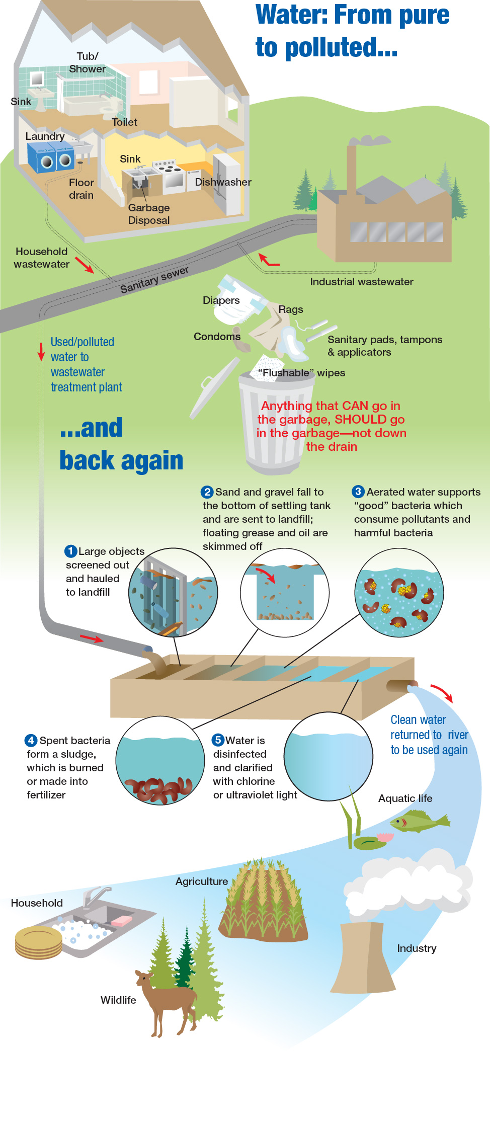
Wastewater Infographic for Metropolitan Council
More stuff visible here http://www.behance.net/PattiIsaacs
Sneak peek:

This is another first for me: a book cover design for the autobiography of Aldo Rescigno, an Italian native who traveled the globe as a researcher, building his career as a world-renowned authority on biomathematics and pharmacology.

La Ricerca (“The Research”) chronicles Prof. Rescigno’s life and life work spanning eight decades and four continents. The cover is illustrated with a world map dating from the time he first left Italy in the early 1960s and a vintage photo of Prof. Rescigno in his office at the University of California, Berkeley.
The process involved obtaining a map source that was of adequate resolution and in the public domain. I placed it so that the west coast of the U.S. and Australia, both places where Prof. Rescigno worked, were visible on the front cover, and adjusted the map’s saturation to keep it in the background yet remain readable. Next, using Photoshop, I scanned and retouched a badly degraded slide of Prof. Rescigno and created a composite of the portrait and a vintage photo border with adhesive corners. Finally, I added and positioned the book’s title and subtitle and the author’s name. The final composition was created in Adobe Illustrator.
The book, in Italian, is available in ebook format from Amazon.com.
A recent story on NPR asks, is book cover design a dying art? Read below.
http://www.npr.org/2012/08/05/157886049/in-the-e-book-world-are-book-covers-a-dying-art
I’m not primarily—or even secondarily—a cover artist, but it seems to me that ebook cover design just switches the model. It forces the designer to bypass the tactile elements that might make a cover compelling on the bookshelf and focus instead on the visual. My approach to this cover was to make simple design that works at screen resolution.
I recently created a map to illustrate the book, Swim, by TV correspondent Lynn Sherr, published by Public Affairs, a member of the Perseus Book Group.

Map with locator inset was created based on a cover image and instruction to give it a vintage feel.
You can see the Today Show interview with author Lynn Sherr at this link:

Range of the Red Winged Blackbird; map for sample iPad brochure app
I have created interactive maps for a sample iPad brochure, collaborating with David Farr of Imagesmythe. http://imagesmythe.com/
In order to view the app and experience its interactivity, you must download the Adobe Content Viewer to your iPad. You can find it here in the iTunes Store:
http://itunes.apple.com/us/app/adobe-content-viewer-for-ipad/id389067418?mt=8
Or search manually in the App Store on your iPad to find it.
After installation, sign in with the following name and password:
n: imagesmytheipad@imagesmythe.com
p: imagepad
After you log in, “Exploring Western National Parks – Sample Brochure” will appear asking you if you wish to download it—do so.
This sample app was created to demonstrate appearance and interactivity, and as such contains dummy data. Most copy is from the Western National Parks Association website. Most photographs are from Stephen Penland. You can view Stephen’s beautiful photographs at his website:
Short video by a Spanish student about Connect, the digital language learning program I worked on for McGraw-Hill.
I’ve added a few new items to the portfolio page: